


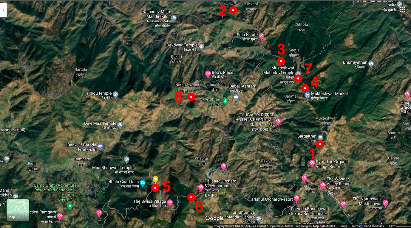
1
Sargakhet to Sunkiya forest
2.5 km
Level of Difficulty- Moderate
It starts at the mobile tower at Sargakhet, goes down through regenerated oak forests and an open field, traverses a ridge and once again descends through forests to end on a tarred road above Sunkiya village. It is possible to follow the trail down through Sunkiya village to reach a forested stream. This trail harbours rich mixed hunting flocks of birds in autumn and winter, and harbours many forest and open country species.
2
Satkhol to Naulikhan (Peora)
1.5 km
Level of Difficulty- Easy
This is a gentle downhill trail that starts at the Satkhol Ashram gate and ends at Naulikhan. The trail traverses mixed habitats of orchards and farms lined with oak and other tall trees, thereafter passing dense tree and shrub covered gullies merging into open Chir Pine habitat. The trail is ideal for sighting woodpeckers, flycatchers and a variety of wintering birds, due to relatively open habitat.
3
Orakhan to Sitla
3 km
Level of Difficulty- Moderate
It passes through oak and pine forests and orchards. New regeneration of pine and cypress post-fires offers a visible contrast to old growth oak forests along this trail. The trail is wide, gentle and is excellent for groups and both experienced and novice nature enthusiasts.
4
Mukteshwar to Sitla
6 km
Level of Difficulty- Easy
The first 4 kilometres is along a largely forested road along the Mukteshwar Ridge, which affords excellent views of snow-capped peaks and of the wide valley below as well as close-up views of soaring raptors. The trail runs along the upper edge of IVRI’s famed Reserve Forests, principally oak-dominated with old planted deodars. The last 2 km of the trail is along the tarred road edged with tall trees, farms and dense hedgerows which combine to make it a lively birding area, both in summer and winter.
5
Dootkanedhar village
3 km
Level of Difficulty- Difficult
It starts at the village and descends along a rock-lined path, goes through orchards and oak forests, crossing a stream and then loops back up to the village. This trail promises excellent views of raptors as it overlooks a steep forested valley and many forest specialists.
6
Thakur
6 km
Level of Difficulty- Moderate
The trail starts at Chipa village and mostly runs through dense Tilonj oak habitat as well as forest edge. The final leg of the trail is on a ridge which offers a spectacular view of both Uttarakhand and Nepal Himalayas on one side and River Gaula in the distance. This trail is ideal for forest specialists, raptors and a number of forest butterflies.
7
Mukteshwar to Sitla
2.5 km
Level of Difficulty- Moderate
Starting at the Mukteshwar Mandir, this trail goes through dense tilonj oak and banj oak forest with a naula in the middle. It worth stopping at the “Vulture Point” in the middle of the forest which gives a clear view of Himalayan peaks.
8
Ramgarh stream
2 km
Level of Difficulty- Easy
This trail starts at the village Kaafaldari which is located between Ramgarh and Nathuakhan. It is a short downhill trail running along the mixed forest edge reaching a large forest stream which is rich in birds, reptiles and butterflies. It is possible to see water birds such as crested kingfisher, white-capped redstart, spotted forktail and . This is also a place to easily observe the Common Peacock, the state butterfly of Uttarakhand and other rare species such as the Purple Emperor and Studded Sergeant, which are seen mud-puddling on the streambed in large numbers, or feeding on garden flowers.